Friday 2nd November – Meadowhall – The sun is shining brightly and I am very warm wearing a fleece which seemed suitable for the time of year. The River Don is flowing sluggishly and looks oily on the surface. The trees around the base of the Tinsley Viaduct are glorious yellows, golds and greens. Great, Blue and Long-tailed Tits are noisily moving through the branches seeking food. Back along to the tram station and over the footbridge which leads to the canal. The tow-path heads towards Rotherham under the viaduct. It rattles with the passing of heavy lorries which sounds disconcerting, but thousands have been spent in recent years ensuring the structure is safe. It looks like the row of shops is still up above the canal wall, only their roofs can be seen from here. The old burned-out Sauna and Massage parlour is still a ruin and adjacent buildings have lost their roofs, but beyond there are new units being built as the area regenerates. Clouds of gnats float above the canal bank. Although we have not travelled very far, Dill the Dog is looking distressed so we head slowly back.
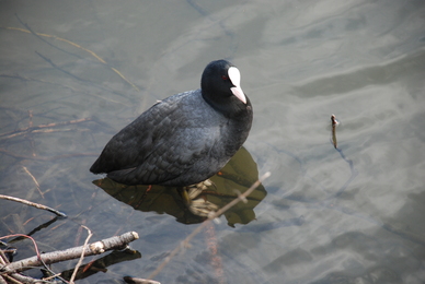
Saturday 3rd November – Newmillerdam – Another sunny autumn day. The fine weather has brought many people out to enjoy this delightful spot. Those with small children are feeding the ducks, which are being challenged for the morsels of bread by Canada Geese and Black-headed Gulls. There are several small pale brown ducks with beaks like Garganey, some feral cross-breed I assume. The trees are magnificent looking, a myriad of autumn colours towering into the sky, whilst the ground is an orange-brown carpet. Carrion Crows are in the woods; one is gurgling and croaking to himself, another wandering up and down a fallen tree trunk inspecting it for food. Mallard drakes have regained their breeding plumage, their bottle-green heads vibrant in the sun. A Great Crested Grebe flies down the lake. One rhododendron has small flowers and many others have fat flower buds on new leaf growth. Tufted Duck numbers are high. A pair of Coot are by the dam wall, one stands on a submerged twig whilst the other dives for food creating a boiling mass of ripples on the surface of the water. The area was known by the Norse name of Thurstonhaugh. In 1285, when it was part of the Chevet estate, a new corn mill was built and the area became known as “New Mylle on Dam”. The mill was probably up near the boat house until 1633 when it was moved to its present site, now a beauty parlour on the north side of the dam, by Francis Nevile of Chevet Hall. It was a soke mill, one of only three in the Manor of Wakefield. These were built by the Lord of the Manor, the Earl de Warenne, for people to grind their corn in return for a “mulcture” or a proportion of the flour, in this case, one sixteenth. Mill owners were often greedy, Chaucer refers to the miller’s “golden thumb” when they took more than their allotted share. This happened in Wakefield in 1463, when Thomas Smith of New Myllne on Dam was fined for taking “excess mulcture”. Originally a small section of the Owler Beck was dammed to turn the cornmill’s water wheel. Today the lake is fed by Bleakley Dike, Lawns Dike and Bushcliffe Dike, the flow of water eventually joining the River Calder at Wakefield.
Monday 5th November – Sherwood Forest – This once great forest used to cover a large area of Nottingham and continue up into Yorkshire where Wharncliffe Woods are the last remaining northern parts. There is evidence that neolithic hunters used the area. Human habitation was more widespread by the late Iron Age and Roman periods. A record of 958CE calls the forest Sciyuda – “the woodland belonging to the shire”. The forest became a royal hunting ground after the Norman invasion and was particularly popular with Kings John and Edward I. The Great North Road ran through the 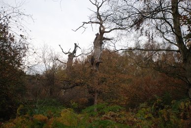 forest and the area was known for robbers, of which Robin Hood is the most famous. As indicated elsewhere in these ramblings, claims for Robin Hood abound the whole area far up into Yorkshire. Certainly, the modern day visitor centre in the Sherwood Forest Country Park does not stint on its exploitation of Robin Hood’s name! The woods were used extensively during the Middle Ages for timber, coppiced for poles, the “underwood”, which was the twigs and brushwood used for fires and the land itself for grazing. In the 12th and 13th centuries various monastic orders owned large tracts, but after the Dissolution the land came into the hands of the great lords, forming the Dukeries.
On arrival we watched a Coal Tit working its way along the bottom of a fence. The visitors centre, although quite extensive, blends well into the woodlands. Paths and information boards guide the visitor through the forest. The 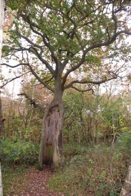 most numerous trees are Silver Birches, many being attacked by the white Birch Polyporus fungus, but the Oaks are the real attraction. Huge ancient Oaks, many “stag headed”, so called for the huge dead branches reaching for the sky, others hollow where the Beefsteak fungus has eaten away the core of the trunks and all of them seeming so venerable. It is hard to imagine that these were not the inspiration for Tolkien’s Ents. The most venerable Oak of all is “Major Oak”. The huge tree is thought to be some 800 years old. Many tales are told of how Robin Hood hid in its branches, but at that time it would have been quite a small tree – or possibly trees as one theory regarding its huge girth is that there were several Oaks all growing in a small space and they fused together to for one massive tree. Another theory is that the trees has been pollarded – cut off about six feet above ground every sixty years or so with the result that a number of crops of timber can be obtained. However, there is little evidence of any other pollarded Oaks in the area. The tree weighs an estimated 23 tonnes, its trunk circumference is 33 feet and its branches spread to over 92 feet. Supports have held up its great limbs since the beginning of the last century. The earliest recorded name was from the mid 18th century, the Cockpen Tree. The hollow interior is said to have been used to pen cockerels ready to be used in the now illegal sport of cock fighting. It was then known as the Queen Oak. In 1790, Major Hayman Rooke, a noted antiquarian from Mansfield Woodhouse, included the tree in his popular book about the ancient oaks of Sherwood and the tree became known as The Major’s Oak, and later simply The Major Oak. The woods are quite quiet at this time of year – the odd song from a Robin, a Green Woodpecker letting forth a single note and a Jay screeching.
Creswell Crags – This is an area of Permian magnesian limestone, laid down some 250 million years ago in a shallow sea called the Zechstein which stretched from here to Poland. A small river carved a deep gorge less than a mile long through this limestone and water action also created a number of deep caves. These caves were given names in the Victorian era such as Mother Grundy’s Parlour, Church Hole, Pin Hole and, inevitably Robin Hood’s Cave. The caves were first occupied by Neanderthals some 45000 years ago. It is likely they only stayed briefly, following herds northwards in the spring and then back south as autumn set in. However, they left behind some stone tools. Modern man appeared in Europe about the same time but did not visit this area until some 30000 years ago. This occupation period seems to have lasted several thousand years then there appears to be no occupation until 12000 years ago. In the 19th century, archaeological discoveries included the figure of a masked man engraved on a piece of bison rib, a fish pattern on a mammoth’s tusk, a chevron pattern on a reindeer rib and a horse’s head on another piece of rib. Stone weapons and bone utensils such as a dagger made of mammoth spine and cups made of woolly rhinoceros bones were also found. Stone tools have been defined as the “Creswellian Culture”, examples of which have been found in the cave in High Wheeldon, Earl Sterndale and as far away as Somerset. However, in 2003, Paul Bahn and Paul Pettitt discovered three cave paintings, one of a crane or swan, one of a bird of prey and the third seeming to be an Ibex, not a species previously thought to have existed in England. Thin layers of Calcium Carbonate which can be dated to 12,800 years ago, cover the art, meaning that this date is the latest possible for its creation. All the caves are closed off to the public to preserve them. A lake has been formed when the gorge was dammed over 200 years ago to provide power for a watermill. A road used to run down the gorge but this has now been diverted and just footpaths exist.
Cadeby – Just outside the village, on the way to Deneby Ings, a number of Carrion Crows were mobbing a Common Buzzard. Yet more evidence of their increasing presence in the area.
Tuesday 6th November – Home – At 4 o’clock in the morning the waning crescent moon sits low in the sky with the brilliant disc of Venus just above it, although of course separated by millions of miles. Aphrodite and Selene, Venus and Diana.
Hoylandswaine – Kay notices as we pass the church of St John the Evangelist that a sign reading “Church Open” is standing outside the gate. So we go to investigate and indeed it is so. There are several parishioners inside, all women and mainly elderly, vacuuming and cleaning. One lady tells us the church is open every Tuesday afternoon when they clean it. They are proud of their new organ which has been brought from Durham and installed for £50,000. The site of the organ has been moved from beside the chancel to under the bell-tower. The church is plain, built in 1867. I am surprised when she informs me that there was no other church on the site before this. The village either used the Methodist church or went to Silkstone. I comment that the church seems to be a long way from the centre of the village with which she concurs, saying some of the older folk find it difficult to get down here and back up to the village. I comment I had met a man who was looking for a watercourse in the graveyard. I was told he had found it and the water table had altered considerably since the new houses had been built in the close nearby. This has caused a lot of subsidence and the altar has moved to one side. In winter there is nowhere for the water to go so it pours down the road and freezes making the road impassible.
Wednesday 7th November – Pugneys Country Park – A quick check in the dog walk area to see if there are any Blewits around, but no. Out in the park a small number of Redwings fly into some tall trees, one adopting their favourite pose right at the very top. Very few wildfowl on the lake, just the usual Canada Geese. Several Cormorants pass over, moving quickly in the high wind.
Friday 9th November – Broomhead – Large areas of the Forestry Commission softwood plantations that cover the hills between Bolsterstone and Broomhead have been felled. It looks like replacement evergreens have been planted. A public footpath runs across Broomhead Park. The stile is steps up and over a high wall. I place Dill the Dog on top of the stile and she jumps, or rather falls off, down to the other side. Her landing is somewhat ungainly and I decide it is probably a bad move. She wanders a short distance a way and I call her back. She can hear me but is looking around wildly, not able to see me. It gets very distressing when I have to almost touch her before she sees me. We wander down the path a short distance but the public footpath enters a field of cows before turning back across the hill and I am not keen on entering with Dill the Dog, so we turn back. A stream runs down this wooded area, through a couple of small tunnels with rough stone entrances. Large Beech trees are surrounded with cast iron fences, saplings have rather less attractive wire and wood stock fences.
Back over the style. There is a large farm house on a three way junction. It and the immediate area is rather splendidly called Wigtwizzle (or Wightwizzle). Up on the Strines Road there is a footpath off across the Broomhead Moor. A cock Pheasant flies up noisily and flaps across the sheep pastures in a most ungainly fashion before dropping behind a wall. Red Grouse are common, disappearing across the heather and bilberry calling “Be quick , get back, get back”. The footpath crosses a stream over what could be called a bridge, whose lintel consists of an old stone gatepost with the fittings still attached. To the west, an earthwork is marked on the map but is not apparent on the ground. Just beyond the footpath leaves the track and heads down the gentle slope. Across the moor, just before it drops steeply down to Ewden Beck, stands a stone circle. Just a couple of stones can be seen above the bracken, heather and rather worryingly, large quantity of young rhododendron bushes which will swamp the area if not controlled.
Sunday 11th November – Barnby Basin – I have often visited this spot, the end of the Silkstone Waggon Road where it meets the Barnsley-Cawthorne road. However, a look at the 1855 map reveals that this place is far more than a few cottages by a main road. Coming out of Barugh, past Barugh Hill with its triangulation post, marked at 350 feet on the map, the road passes under the M1 motorway. On the old map there is a inclined plane running along Higham Bottom and past Royd Bridge with an engine further on towards Higham. This is now the route of the motorway. Down from the M1, the Silkstone Coal Branch railway crossed the road, an embankment ends by the road and the footings of a bridge are on the other side. Next is the turning onto the track that once held the Waggon Road. Opposite is a white cottage, a row of cottages, now Keel Cottage, at right angles to the road and more cottages and farm buildings beyond. It was in the sunken garden of Keel Cottage that the Barnsley Canal ended in Barnby Basin. Beside the white cottage was once an office and the occupants of the cottage in the 1850s was Thomas and Martha Hawksworth, Thomas being a tax collector for the Canal Company. In the early 20th century, sweets, ice cream, cigarettes and pop were sold from the premises to families on their walks to Cawthorne. Behind the white cottage stood “The Jolly Sailor” public house, now part of the buildings of a house. It was recorded in the Barnsley Chronicle in 1937 that a Mrs Parr recalled the sign of the pub being an old tar in a blue sweater holding aloft a tankard of ale. Between the basin and the railway were lime kilns. We walk up the path the runs at an angle to the Waggon Road. This path was previously called “North Lane”. Tendrils of scarlet berries of Black Bryony hang down the hedges. We turn down to Barnby Furnace, now several cottages and back along the Waggon Road.
Monday 12th November – Fountains Abbey and Studley Royal – In the valley of the River Skell stands one of Yorkshire’s great monasteries, Fountains Abbey. Following the Conquest, the Benedictine abbey at Whitby was restored and monks from there established, in 1088, the house of St Mary’s in York. In 1132, a dispute broke out at St Mary’s with reformers led by Prior Richard wanting a return to the basic principles of St Benedict. This occurred when a group of the austere and disciplined monks of the Cistercian Order passed through proclaiming “joy in poverty”, on their way to found Rievaulx Abbey. Thurston, Archbishop of York, interceded on behalf of the reformers and after a riot in October 1132 he took 13 monks expelled from the abbey into his protection. These monks made their way to Ripon and then onto the valley of the River Skell to found Fountains. The abbey may have been named after the springs on the banks of the river or from St Bernard de Fontaines, known as Bernard of Clairvaux. The community did not thrive and in 1133 the monks sought aid from Bernard and his Cistercian Order. By 1135 the abbey was thriving and  was admitted into the Order, despite the reservations of the original group who did not fully accord with the high degree of organisation and direct papal control of the Cistercians.
By the mid 13th century, Fountains Abbey was one of the richest religious house in England, mainly through wool. This resulted in the austere idealism of the founders to be lost as estates were extended and grandiose building project resulted in massive debt. This was exacerbated by the Black Death, bad harvest and raiding Scots. However, Fountains was still important within the Cistercian Order with a revival in the early 16th century under Abbot Marmaduke Huby. As with all such institutions the end came with the Dissolution by Henry VIII in 1539. The abbot came out of it well with a pension of £100 per annum, with his monks receiving £6, the customary stipend of a country priest. The lands and abbey were sold to Sir Richard Gresham, a merchant and resold to Stephen Proctor who built Fountains Hall. Proctor was a Protestant who was knighted by James I and used by the king to hunt down adherents of the Old Faith. However, after  Proctor’s death, the hall and abbey ruins was in the hands of the Catholic family of Messenger who sold it to William Aislabie in 1768. On the hill high above the valley is a splendid visitors centre. From here a path winds down and reaches the valley floor by the Porter’s Lodge where a senior monk would have guarded the entrance to the abbey. Long-tailed Tits and a Nuthatch are feeding in the trees. The ruins are extensive and magnificent. A huge Perpendicular North Tower built by Huby is mainly intact although its floors have long gone. There is still a statue in a niche high on the south face thought to be of St Bernard. It is unusual to find any statues left in ruined abbeys. The buildings surround a large cloister with the church to the north. A long nave leads to the choir which is flanked by the south and north transepts, the tower being off the north. Next is the presbytery and the high altar, the latter a raised platform covered in tiles collected by William Aislabie. There are few tiles in this abbey, compared to other houses, reflecting the original austerity of the Order. Beyond the high altar is the Chapel of the Nine Altars constructed in the early years of the 13th century and adorned with columns of the local Nidderdale marble. When a Perpendicular window was inserted into the Chapel, fractures appeared in two of the windows. These were concealed by figures, an angel on the inside of one and a Green Man on the outside. To the south, the River Skell runs under some of the
  buildings through arched tunnels. Bats roost in these tunnels and can be seen emerging on summer nights. Within the walls are occasional piles of feathers showing that a raptor has been helping itself to the many pigeons on the ruins. Jackdaws are noisy around the whole valley. The lay-brothers’ refectory still has its arched roof and is a long hall with windows with a reredorter built over the river leading to the infirmary.
To the west of the abbey is Fountains Mill, built in 1140, making it the oldest building on the site. In one building is an “Acoustic Jar”, a pottery jar set into the stone walls of the choir to amplify the monk’s voices. The main building, now a museum, has a waterwheel inside along with corn grinding displays. It was far too valuable to demolish at the Dissolution and subsequent owners have maintained it. The surviving wheel was added in 1840 to drive a sawmill. A hydro-electric plant was added at the end of the 19th century and enlarged in 1927 when the waterwheels were removed. Outside the entrance to the abbey grounds stands Fountains Hall built by Stephen Proctor between 1598 and 1604, partly using stone from the abbey. It has a façade of large windows, similar to to the style of Robert Smythson who built Hardwick Hall and Burton Agnes. Stairs lead up to the main rooms. At the top of the stairs, behind one, is a monuments to Elizabeth Vyner WRNS and Charles de Grey Vyner both of whom died in the Second World War aged 18 and 19 years old respectively. The monument was dedicated by Queen Elizabeth the Queen Mother in 1953. It shows a Wren and an aviator looking up at the Cross with a glass engraved panel: “When You Go Home, Tell Them Of Us, And Say, For Your Tomorrow, We Gave Our Today”. The Vyners are descendants of the Aislabies.
Studley Royal – East of the ruins are the magnificent gardens of Studley Royal and Deer Parks. The gardens were planned by John Aislabie in the early 18th century. However, personal disaster struck in 1720 when he was one of the principal promoters of the South Sea Company scheme. This vast financial operation collapsed in what is known as the South Sea Bubble and he was expelled from Parliament and banned from holding public office for life. After his death in 1742, his son William completed the scheme by purchasing the ruined abbey and incorporating them in the design. Down the valley, the river sweeps round a high hill, called Tent Hill, into a fine lake. Coots and a flock of 12 Little Grebe are  on the water. The lake is held by a “rustic” bridge and below is a canal with a statue of Hercules and Antaeus on the grass sward beside the water. By the bridge is a little cave with a seat called The Quebec Monument where a small cannon used to be fired on 13th September to commorate the capture of Quebec in 1759. Beyond is a formal water garden with a Temple of Piety. The garden is a large circular Moon Pond with Crescent Ponds either side. Neptune adorns the Moon Pond with Bacchus and Galen in the Crescent Ponds. Four more statues used to stand here but they have disappeared. On the steep slope above the formal gardens are buildings hidden in the woods – Anne Boleyn’s Seat, the Temple of Fame and the Octogon Tower. The river enters another large lake through a cascade with rusticated columns and pavilions either side of the dam. From here the path heads up onto the Deer Park where there is a herd, mainly of Fallow Deer with a few Red and Manchurian Sika. The stables are now a private house. The Church of St Mary is a High Victorian Gothic building by William Burges built in the 1870s. It is only open during the summer. The appears to be a statue of a stag beyond the church, until it turns around! The “base” is a doe laying in the grass. Looking back from the church, the eye follows a long lime avenue to the East Gate and Ripon Cathedral in the distance. A path leads back to the visitors centre.
Wednesday 14th November – Willowbank – A plume of steam rising from Royston coking plant drifts south and merges with the cloud cover. Dill the Dog is fairly bouncing along – this must be a “good day”. Horses are neighing up towards the top path. A young horse comes galloping out of the path by the pit-heads and charges up the hill, whinnying to itself. It must have got separated from the main herd and is rushing back. Blackbirds are chuntering alarm calls in the Hawthorns. Many of the leaves have now fallen. Magpies are noisy and Jays screech further down the valley. Bill comes through with the new spaniel, Benjy. Dill the Dog adopts the “grumpy old lady” mode and makes it clear she does not want a puppy jumping on her.
Friday 16th November – Barnby Basin to Norcroft – I start again at Sunday’s setting-off point and head up North Lane. The lane was metalled at some time, but it has mostly broken up and there is now only a path worn into the ground now. Common Pheasants are feeding in the fields. Someone is shooting over the fields, some distance off and Dill the Dog cannot hear it, so there is no panic as there would have been once. The noise from the M1 motorway is very intrusive this morning. It is cold and damp. At the top of the path, the track from Barnby Hall crosses and heads down to Barnby Forge. North Lane continues although it is almost hidden by a large tree. The path is narrow and rough. It looks like it was cobbled with large pieces of sandstone which are now raised and broken by tree roots. The field fences indicate the original width of the lane. Blackbirds flit around the bushes. A pair of Bullfinches fly silently away. A path leads off up a hill which has a few trees atop it. This path also leads over to Barnby Hall. The path turns gently this way and that whilst maintaining a south-westerly direction. At some point, it is not clear as paths seem to have moved and fields changed, Adam Lane leads off in a westerly direction. North Lane drops and comes to crossroads, although the right-hand “turning” is only a small path and always was thus. Further on another footpath crosses a field to join Adam Lane where it leaves the Silkstone-Cawthorne road. A cottage is on the junction. Either the cottage or the area was called “Adam Lathe” on the 1855 map. Over the road is Lower Norwood, a farm. A capped airshaft is beside the road. Down the road to the junction with North Lane. The road bends beyond this point over Norcroft Bridge. Looking at the line of the road it would indicate that the main route was up North Lane, rather than the current road. From here, Bank’s Hall can be seen on the hillside and Silkstone church peeping over a garishly pale estate of bungalows. Back up North Lane to the footpath and down the opposite direction onto the Waggon Road. The track has been surfaced with hardcore but the old stones that held the rails can still be seen in places. Past Low Mill and the old forge and back to Barnby Basin. Dill the Dog is very tired now and grateful for a drink of water and the back seat of the car to flop down upon.
Monday 19th November – Earlsheaton – The weekend was damp and cool and the wet weather continues this morning. There has been a report of a Bronze Age barrow having been found at Mitchell Laithes water treatment site. I park near the site but it is clear that nothing will be seen. Dewsbury took over the sewage farm here in 1879 and are currently upgrading it. There are diggers and cranes everywhere and it is not be possible to enter. Also, the area of the site is massive, stretching right across the Lower Calder valley. A digger is excavating a slurry pit near the road. The black, dry material being dug up is steaming and stinks. I cannot image spending the whole day in such a malodorous occupation. Before the sewage works were established in the latter half of the 19th century, the area was marked on the map simply as “Sands”. Above the road is a large hill which drops down to the road ending in a small cliff. An Oak is perched precariously on the top, with lots of roots reaching out into thin air. Back up the hill towards Earlsheaton are some older cottages and more modern houses. In the early 20th century there was a substantial isolation hospital here, Mitchell Laithes Hospital (Infectious Diseases). Back in the village a road drops down, Middle Road, with Low Road descending to the River Calder flood plain. Here stands a substantial industrial site. The main part of Earlsheaton is on the top of the hill above the river valley and stretching back towards the Dewsbury-Wakefield road. The name comes from hea tun meaning “the settlement on high land” which was owned by an earl, apparently the Earl of Warren and Surrey, William de Warren II. The village grew around the woollen industry and a large mill, Hoyle Head stood where there is now housing. The centre of the old village has mainly been demolished and replaced with modern housing. The original parish church, St Peters, has also gone. Around Town Green are a few older buildings but mainly rather unattractive post-war dwellings. A large park, which would have dog-legged around Hoyle Head Mill, is a pleasant open space. Slightly towards Dewsbury is a Victorian cemetery which seems to have been dug out of the hillside. Old maps show a chapel here.
Thursday 22nd November – Penistone – After being cooped-up indoors for several days with a heavy cold, it is good to get out, even if it is only a visit to the weekly market. It is busy with folk doing their shopping. Snippets of conversation are overheard as we pass, including the wonderful exchange: “21st December is the shortest day.” “Ah well, who knows with all this climate change.” We call at Paul the butcher in the High Street and then Ray, the cheese and bacon vendor, who also does a line in fine pork pies! We then head back over the hill to the farm for some vegetables and logs for the fire.
Saturday 24th November – Silkstone Fall – Into the old woods to collect wood for tinder. Everywhere is damp. The fallen leaves are a sodden layer on the ground, none of the crispy piles of a few weeks back. The sticks I am gathering are cold, wet and slimy with a thin coating of moss, but they will soon dry out by the stove. Apart from a distant twittering of a Long-tailed Tit flock there is silence.
Monday 26th November – Fleets Dam – The grey, damp days continue. We are both still coughing and spluttering with our colds. The Fleets look bare and uninviting. A few Mallard float quietly on the eastern side and several winter-plumaged Great Crested Grebe are at the south end. No gulls, no Cormorants and nothing singing – the dull end of autumn.
Tuesday 27th November – Kirkstall Abbey – This site is one of the ten most important monastic sites in England. In the 1140’s Henry de Lacy, Baron of Pontefract became seriously ill. When he recovered he gave thanks by giving Fountains Abbey land at Barnoldswick near Skipton so they could build a daughter church. In 1147 Abbot Alexander led a group of monks to the site to establish a new abbey. They soon fell out with the local populace after they threw them off their land and pulled down their church. The local people complained to the archbishop and to Rome, but as the archbishop and the papacy were both Cistercian they ruled that an abbey took precedence over a local church. Not surprisingly, the monks received no further gifts of land from the local people and little aid when their crops failed. Further instability was caused by the civil war between King Stephen and Matilda and the loss of many possessions to robbers. Abbott Alexander decided to move. Henry de Lacy assisted by encouraging his vassals, particularly  William de Peitevin, to give land in the Aire river valley near a small settlement called Leeds. On 19th May 1152, six years to the day they had left Fountains, the monks founded Kirkstall Abbey. The abbey was built between 1152 and 1182, the year of Abbott Alexander’s death and, unlike many other Cistercian abbeys, was largely unaltered until dissolution in 1539. As in other cases, the monks left the abbey with reasonable pensions.
After dissolution, Kirkstall Abbey was given firstly to Thomas Cranmer, Archbishop of Canterbury, and then back to the Crown. It was then tenanted to Thomas Pagenham. Robert Savile bought the site in 1583 and it stayed in the family until 1671 when it passed by marriage to the Brudenells, Earls of Cardigan. The major buildings were still standing at this time, although their roofs and furnishings had been stripped. However, time took its toll and the roof, west wall and vaulting had collapsed by 1746 and the tower fell in 1779. The ruins were very popular with the artists of the Romantic Movements, including Girtin, Rhodes, Farington and Turner. The site is set between the River Aire and a major road, the A65. The Abbey Manor House,  built as the gatehouse in the late 12th century, now restored as a museum, stands on one side of the main road, the ruins on the other. Much of the church is standing. As we arrive at the site, a skein of geese fly over high above. The long nave leads to the quire and then to the presbytery where the high altar would have stood. The great rose window is reduced to a few small stubs of stone. Six side chapels line the north and south transepts, each with a piscena. Outside is a peaceful cloister of a green lawn surrounded by stone walls with sitting places. The main domestic buildings of the monastery are closed off to the public at the moment. However, walking around the perimeter fence, it is possible to discern the layout. Many, such as the abbot’s house, are in fair condition. The Guest House has been reduced to low walls. Feral Pigeons and Jackdaws fly around the tall remains to the tower and rest on the top walls of the nave. A Pied Wagtail is calling somewhere. Down on the Aire, a sole Mallard comes to see if there are any titbits available. It is dragging a wing in the water which may be broken. Gulls gather on the extensive playing fields on the far side of the river. We walked along the river towards Leeds a short way. The river bends over a wide weir. A stone dam is across the edge of the river as it turns. There is a stone building here, presumably housing equipment to raise and lower boards in the dam. This is a goit, or mill race, probably first dug in the 12th century to power the monks’ corn mill.
Ben Rhydding – A small village outside Ilkley in Wharfedale previously called Wheatley. In 1844, Hamer Stansfield, a former Mayor of Leeds, having visited, and been impressed by, Graeffenberg Spa in Silesia, returned home and built his own establishment in Ilkley at a cost of £30,000. He called it “Ben Rhydding”, allegedly the name of the hill rising above the village. By the end of the century, the name Wheatley was lost and the area had gained its present name. There is a row of shops, including a fine traditional butcher selling good pies!
Ilkely – We spend a short time in this old spa town. It stands in Wharfedale below the famous Ilkley Moor. Flints from the Mesolithic, 11,000 BCE have been found in the area and the site was continually occupied from the Bronze Age, circa 1800 BCE onwards. The Romans built a fort here, possibly called Olicana, near the town centre but little remains as an Elizabethan manor house was built on the site. Ilkley (or Ilecliue/Illecliue/Illiclei/Illicleia) was named in the Domesday Book as belonging to William de Percy, 1st Baron Percy. It became popular as a spa town in 17th and 18th centuries. It is now a relatively prosperous dormitory town for Leeds and Bradford. There are some decent shops although a preponderance of jewellery and arty type establishments. The famous Harrogate tea shop, Betty’s, has a place here. We head up towards Ilkley Moor past some very large Victorian houses and mansions. It is bleak up here and we do not tarry long, indeed just long enough for Kay to say she has been on “Ilkley Moor Baht’at”, in the words of the old song.
Wednesday 28th November – Barnsley – Through a busy town centre. Starlings are chattering as they gather around the ornate roof of the old Co-op, now a bar like many former retail outlets around here. Onto Sheffield Road. The Manx pub, an old dive of mine I have not been in for years, looks in reasonable shape which is more than can be said for much of the road. The next pub, called “The Office” in its last incarnation is closed and the façade is rotting and falling. Many shops are boarded up. The “goth” shop is still open after many years – a genre one would think as transient but it has been here as long and far longer than most. A fairly new enterprise is a food shop specialising in Polish provisions. Down Quarry Street are a few older properties. The area was a network of linen weavers cottages with looms downstairs and living quarters up. They have all been cleared away in the 50s and 60s to be replaced with dull modern estates. Up Mount Vernon Road, lined with early 20th century houses, mainly semis. To the west is a large Council estate, Worsbrough Common, which is built on what was indeed the old common. The original hamlet here was called Dillington.
On the top of the hill is Mount Vernon Hospital, built in the early part of the 20th century as Mount Vernon Tuberculosis Sanatorium. Beside the hospital is a track leading through High Stone Plantation, High Stone Fold and onto Castle Hill. There was an Iron Age encampment here. Opposite the hospital is a field and lane leading to Bank Top. William Elmhirst (1480-1560) held the land here and it now takes his name. In October 1840 a notorious murder took place here. George Blackburn had been out collecting monies due to him for milk and other items and was killed and robbed on his way into his home. Four men were charged with wilful murder but three were acquitted, the fourth, John Mitchell found guilty and sentenced to hang, but this was commuted to transportation for life. A goat sees me at the field gate and trots over, wagging its tail. Unfortunately, I have no titbit for it. The road descends into Ward Green. A triangular field used to contain the pinfold, where stray animals were kept. The far side is again a large housing estate, but was once a few houses called King Well. From here the view looks down to Worsbrough Reservoir which is sitting under a cloudy sky with shafts of sunlight slanting down. Genn Lane leads off and makes a sharp turn to Ouslethwaite Hall, a large house and outbuildings – barns, stables and granary – all converted into dwellings. Another William Elmhirst (1721-1773) bought the property from Thomas Hammersley, banker to the Prince Regent, in 1769. Hammersley had obtained the property through his marriage to Elizabeth, daughter of Thomas Archdale. The Archdale family had inherited the property from the Genn family, who were intermarried with the Elmhirsts over many centuries. Further along Genn Lane is a new Farm Shop which has been the subject of much debate. However, it seems an unobtrusive site and sells local produce, including a reasonable pork pie. My ramble now takes me through Locke Park, then down Racecommon Road back into town.
Friday 30th November – Willowbank – The sky has a patchy covering of grey nimbus clouds but the sun has broken through. It is mild. Down the hillside it is fairly quiet but there is the chatter of avian life – chuntering Blackbirds, squeaking Blue and Great Tits and meeping Bullfinches. A pair of males of the latter fly off with their gaudy pink waistcoats and grey backs, flashing pure white rumps. Moles have been active and raised black hillocks. A Robin flits between Hawthorns. A sunbed has been dumped across the path – what sort of mentality drags rubbish this far to dump it, particularly as it is about ¼ mile to the dumpit site. A large flock of pigeons is on the winter wheat field over the other side of the River Dearne. Dill the Dog is walking fairly well this morning but tarries on top of the hillock near the top. I turn around and she is looking around in every direction but cannot see me. I have to go back and wave my arms around and she eventually realises where I am. Anybody seeing this episode must wonder what is going on!
Barnsley – Another local ramble. Headed over the hill and down towards Townend. Then turned up Station Street. At the top is a bridge over the Barnsley-Penistone line and the remains of the old Summer Lane Station that named the street. It is now little more than a few decaying bits of wood. Then down Farrar Street and round to Springfield Street. I last described the district in January 2002 and some things have changed since then. The house with the scruffy scrolling around the gables has been entirely renovated with all the scrolling gone and new double-glazed windows. The large factory is now offices for the Borough Council. It is now possible to walk down to the car park and see  Sough Dike. I had supposed in my earlier rambling that the factory was built on the site of an earlier one, but the 1894 map shows no building there. There is not a lot of water in it and the surface is covered in leaves. Grange House remains an impressive building with extensive gardens which is shown on the 1894 map, but not on the 1855. I cut up the ginnel onto Dodworth Road and up to the large green leading up to the junction of Pogmoor Road. In the early 20th century, there was a brickworks and tramway on this green. I can recall a model railway track there some years ago, but it is now gone. There are clumps of fungi across the green, probably one of the Honey Fungus, which indicate where trees have been chopped down and their stumps sawn off to ground level.
Pogmoor Road was a footpath well into the 20th century and in the 1930s was called West End Road. The whole area is now covered in houses. It crosses the railway and bears right. Farm House Lane leads off to the left. It once ran down past the Tommy Treddlehoyle pub (named after Charles Rodgers (1802-1874), a writer, artist and wit, friend of Joseph Broadhead (Water Joe). Rodgers was known throughout England in Victorian times), to join the Pogmoor Road but now all of this road is known by this name. Farm House Colliery was a little down the road to the right. My path is down what remains of Farm House Road and over a stile into fields. There is a small patch of gorse and this is probably all that remains of the original Pog Moor. The path crosses a field containing sheep and some miniature horses that are bred by a farm that stands where the old Hermit House stood, giving its name to Hermit Lane. A stream runs out of a pipe in a small valley. Its source was called Drury Spring, which became the name of the wood that no longer stands here. In the 19th century the footpath ran along the edge of Hermit Wood, but this has been felled. After several stiles I head up across the field that leads to the Hermit public house and Higham. In fact the footpath turns down to Hermit Lane but it is not marked, nor is it clear on the ground. This field has a sizeable herd of horses. One group gallop up the field to the main herd on the top of the hill. Seeing a charging herd of horses coming up the hill leads to a few nervous moments. Having reached the top of the field I discover no exit. So I step gingerly over an electric fence and clamber over the wooden one. Down the road to The Engineers pub, a Samuel Smith’s house. They are a strange old brewery, right next to John Smith’s in Tadcaster, although there is no connection between them! Everything in a Sam Smith’s pub is provided by the brewery, all the beer, spirits, mixers, squash – everything is their own brand. But the most impressive bit is that their excellent hand-pulled bitter is £1.26 per pint, when I can think of no other pub locally selling a pint under £2! So I stay for a pint or three and read the paper whilst listening to the old regulars banter.