Tuesday 1st May – Emley – A track, once known as Tyburn Lane, runs from the Skelmanthorpe road back towards the village of Emley. The sun is blazing down. A path leads around the hill. I sit for a while on the damp grass – dew not rain! A long hedge of Blackthorn and Hawthorn runs behind me. In front the land drops away across 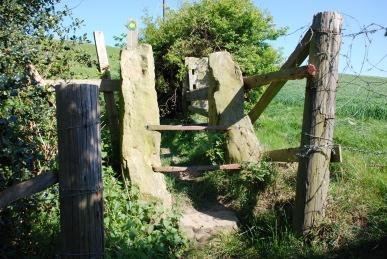 Emley Park to Skelmanthorpe. The park is now fields of verdant grass, one containing cows. It was part of the Savile Estate. The eastern area is called Park Mill and a mine was sited here. To the west is Park Gate and then in the distance, just below the horizon are the windmills of Royd Moor wind farm. The dark line of the Pennine Moors form the horizon. Whitethroats, Willow Warblers and Linnets are all singing nearby. Starlings drop into the field below and vanish into the grass. The path climbs towards the edge of village. Emley means “Emma’s Field” and was founded by the Angles, although evidence has been found of Iron Age and Roman presences. The village was destroyed in 1069 by William the Conqueror as part of the “Harrying of the North”. Further up the path a freshly broken pigeon egg lies on the ground. I do not enter the village but drop down beside Church Hill Farm, past a splendid old farmhouse with tall chimney stacks. However, the farm is not as old as it looks. It is not present on the 1854 map, but is there by the end of the century, marked as Kirk Hill Farm; Kirk Hill being a high point to the east. The houses on the hill top were once in a place called Warburton where
  there was a Methodist Chapel that stood there in the mid 19th century. Dill the Dog manages to get lost here, taking the wrong path whilst dawdling behind me. Past the farm we are followed by a goat, until the farmer grabs it by the horns and marches it back. The hillside above is the brilliant yellow on dark green of Gorse. Further on a pair of Partridge whirr up out of the grass and over the hedge. At a field junction the path traverses a stile made of two large, triangular pieces of sandstone on edge with thick iron bars stretchered across them. The path drops down beside a field, past a large Oak coming into leaf. At the bottom of the hill, I head up a bridle path and across a cow field. The path then doglegs onto another bridle path, which seems to be called Frank Lane on the 1854 map. The track goes past Low House Farm, where a splendid cockerel crows and the farm dogs bark furiously at Dill the Dog, who is almost interested for a moment. Swallows are sweeping across the fields. Suddenly, an oversized Swallow flashes into view – a Merlin. The little falcon arrows across the fields and rises up over the farm and is gone. Large numbers of black flies float in the air – probably St Mark’s Flies which usually appear around St Mark’s Day (April 25th). A welcome breeze is developing. There is an abundance of Crosswort alongside the track. It is a pretty plant with bright green leaves forming crosses up the stem and tiny clumps of yellow flowers at the base of each leaf. Vetches are also about to flower.
Wednesday 2nd May – Carlton – A stump of a cross – the Kirk Cross – stands beside the road on the border of Carlton and Royston. An abandoned railway track runs off from the main road towards Shafton. It was the Wharncliffe Woodmoor Colliery Branch which was taken out of service in 1967. The track is lined with Willow, Oak and Birch. The path takes a surprisingly steep drop into open fields. Here Dill the Dog meets a friendly Alsatian, but being Dill the Dog, after saying hello walks off in the wrong direction. The Alsatian’s owner guides 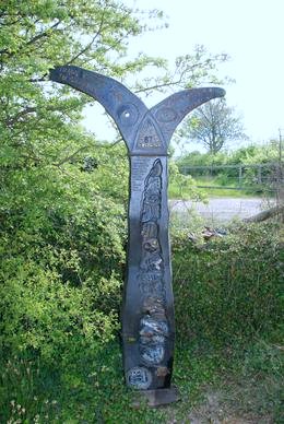 her back to the right path. “Is she knocking on a bit?” he enquires. “Yes, fifteen.” I reply. “Ah well, it happens to all of us,” is the response. The track then meets the Barnsley Canal and Trans-Pennine Way. There is a nice iron way-sign, one of a thousand mile posts set up by the Royal Bank of Scotland to commemorate the establishment of the National Cycle Network for the Millennium. It has a fish shape, with the forked tail indicating the directions of Barnsley and Wakefield. On the body of the fish is a montage showing fossil sea-life at the bottom and up through a human skull to parts of car, steering wheel, petrol pump and fuel gauge at the top. A path leads up Cronkhill Lane back to Carlton. Carlton is an Anglo-Saxon settlement, meaning “Farm of the churls or freemen”. At the road junction stands St John the Evangelist Catholic Church. It has an unusual tower that has a sloping tiled roof (it can be seen clearly in the background of the playing fields in “Kes”, Ken Loach’s film of Barry Hines’ book, “A Kestrel for a Knave”). There is a round external stairwell to the bell tower, which has louvred bell-openings. The church was built by G.E. Street in 1878. The priest has administered to his flock, which seems to number two, and is locking up, so as usual I am unable to see the interior. There are no gravestones here as the cemetery is about one hundred yards up the road in the Royston direction. Next to church is, what I assume to be, the Manor House. They used to sell plants here, but no more. A barn in the house grounds abuts the street. It has a filled in window in the same pale sandstone blocks that has been used to construct the buildings around here, but retains the broken hinges of a former window or hatchway. Over the road are more barns that have been converted in residences and a cottage dated 1873. A shop is next to a house called “Old Co-op Cottage”. The shop has the goods winch and second storey goods door on the side but instead of being the village grocery, it is a tanning studio. The Wharncliffe Arms public house stands on the next road junction.
Thursday 3rd May – Worsbrough Mill – After a dull morning, the sun is now shining brightly. Last autumn the mill stopped grinding as the grain hoppers needed relining. It is now back in operation and I can get bread flour again. However, there is no soft wheat flour. The assistant tells me that the dry summer and autumn last year resulted in soft wheat grain simply not swelling and, consequently the price of grain has rocketed. They believe they simply could not sell it at a sensible price. For the same reason, a bag of rolled oats has risen from £1.20 to £2.00 as a sack of oat grain has gone from £16 to £26. They are worried they will not be able sell the stock they have at that price and are unlikely to stock it again unless the price falls. The fact that it has not rained for nearly six weeks now does not bode well for this year’s crop.
Friday 4th May – Fleets Dam – Again the morning is grey and slightly chilly. A Kingfisher speeds down the river like a miniature exocet, turning slightly in air to wink a chestnut breast before disappearing with a turquoise flash. There is a thump behind me – Dill the Dog has somehow fallen off the log blocking the path and ended up on her back. She scrambles to her feet looking dirty and a bit distressed. I brush her down and with quick shake she forgets the incident and trots off wagging her tail. Three Great Crested Grebes and several Mallard are on the lake. Black-headed Gulls and a couple of Common Terns are circling the water. The terns are being successful in catching small fry and keeping them away from harrying gulls. Blackcaps, a Garden Warbler, a Whitethroat and Chiffchaffs are in song. A Grey Heron drops into the lake and rises in an ungainly manner with something in its beak. A Black-headed Gull gives a half-hearted chase.
Old Town – Late morning and it is still grey and trying to rain. My first Swift of the year crosses the sky.
Sunday 6th May – Home – Mid-afternoon brings a sudden and quite violent scrap between a Blackbird, Magpie and Collared Dove. I do not see it start, but after much flapping and kicking at each other, the Collared Dove retreats to the garage roof, the Blackbird up into the apple tree where it pinks loudly and the Magpie struts around the garden, obviously considering itself the “winner”. The anticipated rain fails to be more than a few drops.
Bank Holiday Monday 7th May – Home – There is another altercation between a Magpie, Collared Dove and Blackbird, this time in the front garden. It seems that the Collared Dove is attacking the Magpie with the Blackbird in support. I would guess both the dove and Blackbird have nests nearby and are not keen on the presence of a corvid predator. This time the Magpie departs with the loud cry of the Blackbird ringing in its ears.
Tuesday 8th May – Woolley Edge – Into the woods opposite the view-point that looks towards the Pennines across the valley carrying the M1 motorway. The woods are Beacon Hill Plantation. Small sweet chestnuts are numerous on the dry ground. A path climbs Beacon Hill, past a old quarry that has left a small, deeply cleft rock face, and out onto an open field containing horses. On the top of the hill is a large tree covered mound. In the south of 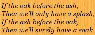 the country, one would automatically expect this to be an Iron Age site, with its siting giving panoramic views across the countryside. However, there is no indication that this is anything other than an old beacon mound – it was here in 1854 according to the maps. There is a gravestone under the trees – “My Beloved Lancer – 3-10-94”, in memory of a horse I would guess. A Chaffinch sings in the trees above. Lapwings dive over the open fields, where Swallows are feeding inches above the ground. Looking back at the woods, it is clear that the Oak is out before the Ash. According to the old rhyme - right, it looks like a dry summer!
Kexbrough – From the Huddersfield Road, the A637, just up from Birthwaite Hall, a public footpath leads up Brook Hill. There is a fair drop from the road down to the footpath, the first 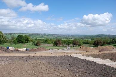 step being very high. A stone wall retains the road. The path goes round the edge of a field containing a grain crop. An old fence runs alongside the brook. The fence posts are old, made of local stone with a couple of holes drilled through to carry the railing. The path crosses the brook and rises to a stile. Beyond is a green meadow with swathes of Bluebells. Yellow Buttercups, white Daisies, tiny blue Germander Speedwell, white umbrella heads of Yarrow and the dark clubs of Ribwort Plantain are all growing in the lush grass. The path comes to a housing estate from which a road leads back down to the main road past an old quarry which would have provided the stone with which the great hall on the opposite hill was built.
Stainborough Castle – For nearly a year now there has been substantial renovation work being carried out at this great house on the slopes above the M1 motorway. A new driveway from Stainborough village leads to a new car park. The old barn behind the church is now a visitors’ centre and café. The church is still undergoing restoration. New paths lead round in front of the house. The old car park with its tall copper beech hedge has been removed giving uninterrupted views across 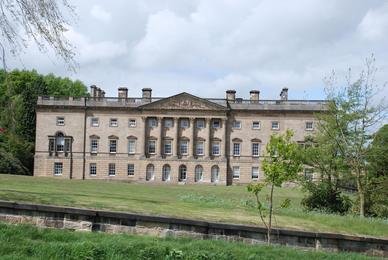 the valley to Barnsley. The path curves round the southern side of the house giving a good view of the Palladian front. The great Southern Ride is being restored. Originally a double avenue of Oaks planted by John Arnold, Head Gardener to Thomas Wentworth, starting on 19th January 1714. The avenue was felled in the mid 20th Century and the area turned over to arable farming. The avenue of Oaks and now Limes is being reinstated. The path curves further around and a new bridge crosses the “Ha ha”. Ha has were a form of ditch
 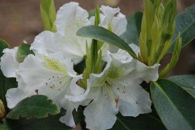 and low wall that prevent stock grazing too near the house without the use of high walls or fences. Over the bridge is the Corinthian “Temple” has been restored, where one can sit and look down the hillside where there were originally fine formal gardens, although these were replaced by the rolling parkland style in the mid 18th century. The gardens to the rear of the house are also undergoing extensive restoration. Many trees have been pollarded and the national collections of rhododendrons, camellias and magnolias are being pruned. We have also visited earlier than last year so the display is much less magnificent. The “castle”, which previously was blocked off because of the dangerous state of repair, has also been restored, although work is continuing and it is not yet possible to climb the tower.
Wednesday 9th May – Barnsley Canal, Old Mill – Two workmen are in the canal erecting a large “Private Fishing” notice. The canal is teeming with tadpoles. Blackcaps, Chiffchaffs and Blackbirds are in song.
Thursday 10th May – Thurlstone – Hoyle Mill Lane runs off of the main Manchester road (the A628) just beside the bridge over the River Don. A terrace of cottages have a plaque “Don Terrace 1935”, although they look older. The river is flowing quietly – last night’s rain seems to have had little effect on the level. Pipes and girders cross the river, guarded by various types of spiked barriers. Down the lane is the premises of a window company. By their showroom, the river flows over a complex little weir. There are a couple of channels and a stone cobble slope. On the other side of the road a path heads up the hill through small dry-stone walled meadows. One is spotted yellow with hundreds of Dandelions. A few Cuckoo Flowers (or Lady’s Smock) with delicate mauve petals are scattered across the grass. There is a very strong wind blowing with the odd spot of rain. Up the hill there is a set of steps leading up to a lane beside a house with large stained glass windows and a date of 1794. Work Bank Lane leads into Thurlstone.
The Domesday Book records Thurlstone as Turolueston or Turulfestune – an interesting hybrid Anglo-Saxon/Viking name, the -tune being the Anglo-Saxon for a farm or estate and Thurulf a Viking personal name. The Book states:– In Thurlstone, (Ing)Birchworth and Skelmanthorpe, Alric and Halfdan had 9 carucates of land taxable; 5 ploughs possible there. Now Ilbert has (them). Waste. Value before 1066 £4. Woodland pasture, 1½ leagues long and as wide. Ailric was the Saxon holding the land, although post-Conquest it was owned by Ilbert de Lacy. Ailric handed the land on to his son Swein (who may well have given his name to Hoylandswaine) and he on to his son Adam Fitzswein. Matthew Gap leads off of the lane past barns all converted into dwellings. This joins Towngate where Thurlstone House is a fine building. Most other houses are conversions of barns, mills etc. The Crystal Palace pub stands on the top of the hill as it drops back down to the Manchester Road. Here the houses are again old industrial buildings – The Old Dye House, Old Corn Mill and the school. Tenter Hill rises from the road – tenters were the frames on which cloth was dried after fulling.
Friday 11th May – Fleets Dam – Welcome rain is falling, cleaning away the dust. Pretty little pink flowers of Red Campion rise above the green of Ransoms and other leaves of plants yet to flower. A pair of terns are screaming high above the lake. Three Greylag Geese are sitting on the water, along with the resident Great Crested Grebes and Mallard. Several Grey Heron are flying around, occasionally being harassed by Black-headed Gulls. A Blackcap is singing high in an Ash.
Monday 14th May – Willowbank – The “welcome” rain of Friday continued in frequent heavy showers all weekend. This morning is grey with just a few drops of rain falling. The ground is sodden. Horses are feeding on the verdant grass. One foal has separated from his mother and quickly trots over to rejoin her as Dill the Dog approaches. Another foal is in the long grass next to his mother by the long hedge. Willow Warblers and Chiffchaffs are singing with just a few squeaks from other species. Looking down to the valley reveals extensive flooding. Hawthorn blossom – May – is covering the bushes like fresh snow. On the way back up towards the Huddersfield Road a lone Lapwing flies over from the direction of the town centre – an unusual place for it to be.
Wednesday 16th May – Fleets Dam – It is raining. Finally enough rain has fallen to raise the level of the River Dearne which is now flowing over the full width of the weir and not just the central channel. A Chiffchaff and Blackbird are singing. A Chaffinch is shooting up into the air and returning to its perch at the top of a tall Ash just like a flycatcher. A Treecreeper is mousing its way rapidly up the Ash branches where there are lots of cracked pieces of bark, but it hardly pauses. A Moorhen swims across towards the water purifiers with a large piece of dead reed in its bill. It clambers up onto the purifier and disappears into the centre of it. Fish are breaking the surface regularly. A dead Roach on the surface is being ignored by both the Grey Herons that are flying to and fro from different perches and the Black-headed Gulls that continuously circle the lake.
Monday 21st May – Fleets Dam – The rain has been minimal for the last few days and the level of the River Dearne has fallen. Now there is only a mere trickle over the higher sections of the weir with the main volume of water pouring through the stepped centre. Bird song is loud and varied – Robins, Blackbirds and Blackcaps mainly. A turquoise flash arrowing across the lake marks the departure of a Kingfisher. Two Great Crested Grebes are displaying by raising their breasts out of the water whilst facing each other and shaking their heads from side to side. Suddenly a third grebe rushes in and chases, what is obviously the male of the pair, off. He flees the charge and dives to escape. Grey herons are moving to and fro, probably six of them. A couple manage to snatch fish off the surface and with a few dexterous moves of their bills slip the wriggling silver prey down their gullets. One of the fish looked like a decent sized Rudd. Blackcaps occupy the tops of trees, singing continuously.
Tuesday 22nd May – Gunthwaite – Dill the Dog and I set off from Scout Dike. The track passes the now privatised outdoor centre of Scout Dike. It looks shabby. A planning permission notice refers to the construction of a “quad bike circuit”. As I head down to Carr Head Farm, I see the circuit has already been built. It must be a joy for the occupiers of the farm house! A pair of Red-legged Partridge fly up from the  path junction. I take the bridleway that heads straight for Gunthwaite Hall. The track crosses the Huddersfield to Sheffield line (called, in 1851, the Huddersfield and Sheffield Junction Railway, although this would have gone straight through Penistone and on to Sheffield and not diverted to Barnsley as now). A train passes with a long blast on its horn. A Linnet sits in the hedgerow. It is very windy with clouds scurrying across the sky. Over the railway through gates with the sign “Penalty for Not Closing the Gate £50”. Bracken is unfurling beside the path. Horsetails are common. Late Bluebells still forms drifts of blue. A Chaffinch sings from the top of a sapling. Sorrel is growing next to the path – its leaves are sharp and can be used in sauces instead of lemon juice. The fields and meadows here are empty, although there are sheep and cows in more distant ones. The area was
 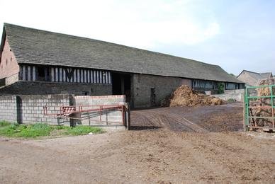 known as Gunthwaite Park. The path passes by two tall dressed stone gate posts. The five-bar gate across the entrance is attached to wooden stakes. The path drops down the hill. It has been paved by large sandstone slabs at some time, but these are broken and mostly buried now.
The path enters Clough Wood, a wooded dell with a stream, Clough Dike, running through it. The leaves are murmuring in the wind and a lone Blackbird sings loudly and sweetly. The track bottoms out muddily over an old bridge crossing the stream. Herb Robert, delicate pink blossoms, line the path. Further along there is a stone tunnel entrance from which Clough Dyke emerges and tumbles down flat layers of sandstone. It has passed under a substantial hill and the railway line. The path continues to rise and enters Gunthwaite Hall Farm. The hall was in the possession of John of Gunthwaite (or de Gunnilthwaite)whose daughter Alice married Thomas Bosville in the mid 14th century. These were the Bosvilles of Ardsley who owned  Cannon Hall and much of the land in the district. The Bosvilles spent little time at Gunthwaite. Godfrey Macdonald, who took the name Bosville married Jane Hardwicke, the sister of Bess (wife of the Sixth Earl of Shrewsbury, jailor of Mary, Queen of Scots), and came to live at Gunthwaite (and the Bosville family or relatives retained the estate until 1982, with only a break from 1952-1963). He built a magnificent barn in 1580 with exposed timber frames that stands today. The hall, built in the 16th century was demolished in the 19th century by the Bosville’s agent, “Mad Earnshaw”. In the Civil War, Godfrey Bosville, son of Ralph Bosville and Mary Copley supported the Parliamentary cause and a troop of Roundheads were stationed at Gunthwaite. It is said that some of these soldiers contracted typhoid during their stay and that those who died as a result were buried near an old oak tree, the remains of which stand in the garden of one of the present houses. Various dogs come to greet Dill the Dog, who really is not very interested.
Here the path joins Gunthwaite Lane and this leads northwards after a sharp bend around a small pond surrounded with a mixture of trees resulting in a  wonderful palette of greens. Chiffchaffs and Blackcaps are in song. The road continues up, back over the railway. A hedge is a mixture of Holly, Beech and Oak with fresh, delicate leaves emerging. Goldfinches flit along this hedge. The bank below is cloaked in Stitchwort, Purple Vetch and Cow Parsley. Over the fields, the land stretches away down the Upper Dearne valley towards Bretton Hall. The road enters Upper Denby which has a good number of new housing developments. A path leads off opposite the church back towards Scout Dike. It travels downhill, lined with Hogweed and Cow Parsley. A tiny stream runs beside the path and looks clean but Dill the Dog refuses to drink, although she must be thirsty by now (as she later demonstrated by drinking a full bowl back at the car!) Swallows skim the meadows. A Pied Wagtail flies over. The path drops down into another wooded dell, Swift Wood, where the small stream joins Clough Dike. There is a signboard of The Countryside Restoration Trust on a tree. The path rises again, and is once more showing signs of once being paved. A Willow Warbler sings from across a field of Sorrel and Buttercups. A Small White butterfly is visiting the flowers. Yet another little wooded dell with a stream that is crossed by a couple of large stone slabs and the path then rises across meadows where hay-making is in full flow. The path re-emerges on the Huddersfield Road. Over on the horizon, all the windmills on Whitley Common wind farm are whirling in the strong breeze.
Wednesday 23rd May – Birdwell – Part of Barnsley, Birdwell is a village to the south of the Borough. Formally a pit village with a few farms about. Its name comes from the Anglo Saxon Brydd-Wella or “Bird-Well”. However, the name first appears in 1642. There is a legend that relates how the servants from the nearby Tankersley Hall found a well of clear water. They saw some large birds drinking from it and decided it must be fit to drink. They collected their water from it, naming it, the “bird-well”. Hay Green Farm is now almost entirely converted into accommodation, with the odd exception of a small house rotting in a wooded grove. Opposite the farm is a small wood where the ground undulates considerably, often a sign of ore mining. Wrens are singing loudly whilst a pair of Blackbirds chase through the trees. The chattering of House Sparrows can also be heard. A back-lane runs behind the main Sheffield Road. Allotments are, sadly, mainly abandoned. The recreation ground is a wide area of grass. The Sheffield Road is lined with terraces and villas dating from the late Victorian period. Just off the main road at the junction with “The Walk” is a tall obelisk with a stone plaque depicting an arrow and the legend, “Wentworth Castle 3 miles 1775”. A fuel tank is rather rudely abutted against the obelisk’s plinth.
A small path that was once tiled, leads down the hill a way towards a small farm house. In the dip below is the M1 motorway. The traffic noise is horrendous! Further down “The Walk”, which is mainly lined with 20th century houses, is a wide area of wood and scrub – Hawthorn, Ash and Sycamore – leading down to the M1. The wooded area continues on the other side of the motorway. On the opposite side of the road there are new apartments. Thus something ran through here, maybe a track-way from the colliery. A ginger cat sits in the long grass watching the gorse bushes for any bird (i.e. breakfast) movement. A little further on is The Cock Inn. It is said that a horse doctor named Longley, remained in the district after the Civil War Battle of Tankersley Moor (April 1643) and built a coaching inn for the travellers between the estates of two rival Wentworth brothers, from the nearby Stainborough Castle and Wentworth Woodhouse. An inn would need water for the travellers and the horses, so it was built near the well. The inn became known as the Cock Inn, possibly after the tap on a barrel of ale or it could have come from the “cock-horse”, an extra horse that was required to be added to the carriages being pulled up the steep incline from Wentworth Castle. This road was known as Well-Gate, from the well and gate the Viking name for a road. Until 1967, the Eastwoods were the only family to hold the beer licence.
Chapel Street leads back towards the Sheffield Road. Small terraces with names such as Victoria Crescent and Rockley Crescent lead off, although there is no evidence of them being crescents. Beyond each small terrace are new builds. The chapel, which is marked on the OS map, has gone and been replaced by new houses. At another point a modern house has been built where terraced houses once stood – the numbering is a give away, the last of the terrace is 9, the new house is 11 and the first of the next row of terraced dwellings is 25. Back on the main road is a tall, three storey Working Men’s Club and Institute. A new extension and entrance has been added on the back. There is a door at the side with what is clearly a staircase leading right up inside of the building, with a slate roof over it. Opposite is the primary school and a newly built Methodist Church.
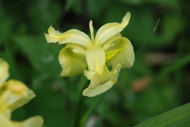
Thursday 24th May – Bretton Woods – The woods are at their best now; trees in full leaf still retaining the freshness of Spring, grasses lush and flowers blooming everywhere. Birds are still in song, maybe not 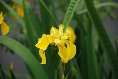 as vibrant as a few weeks ago, they now have nesting duties. Blackbird, Robin, Blackcap, Wren and Chaffinch voices are all heard. A breeze is swaying the branches. By the pool is a display of Yellow Flag. Most are bright chrome yellows but a few have a paler, more delicate yellow flower. Two pairs of Tufted Duck watch Dill the Dog and me warily. One male keeps tossing is head. An occasional fish breaks the surface to snatch at one of the myriad of insects on or just above the water. A Chiffchaff joins the bird chorus.
Scissett – One of the villages in the Upper Dearne Valley, Scissett is a relatively recent development. Great Scissett Wood is mentioned in the Domesday Book and it is thought that there were a scattering of houses by the river. There were a number of mills for fulling and scribbling wool in the valley. In 1825, Joseph Norton, son of Benjamin Norton who was a textile merchant and clothier (someone who outsourced wool to weavers and collected and traded the finished products), bought Highbridge Corn Mill. He realised that transporting raw materials around the district to the weavers was costly and time consuming, so he built houses for the workers at Scissett. The village developed from that point and in 1980, the 150th Anniversary of the founding of the village was celebrated. Along the main road is a mixture of houses and buildings from the founding onwards. A large building, now consisting of housing and a bookmakers, has the sign – “Cinder Hill Terrace 1884”. An interesting name as Cinder Hill is more usually connected with metal working, although it may refer to burning trees as the land was cleared. The Italian Restaurant looks like a chapel, the foundation stone laid by Lady Beatrice Lister Kaye, daughter of the 6th Duke of Newcastle-under-Lyme and wife of Sir Cecil Lister-Kaye 4th Bart. of Denby Grange. Dearne Terrace, part of Barnsley Road, leads down to the bridge over the river.
The church, St Augustine’s, stands on a slight hill at the junction of the Skelmanthorpe road. Graves from the early 20th century remain by the wall that separates the grounds from the road, but the main area of grass is devoid of burials. This is probably because all the gravestones have been lifted and form the path to the church. The bell tower has strange circular features which look like a clock face has been removed. The clocks themselves are higher on the bell-openings of the towers. There are fine trees in the grassed area, Yews, one leaning at an alarming angle, a large Plane and a Weeping Willow whose leaves are yet to emerge. Atop the willow is a Carrion Crow whose calls are matched by the raucous noise from a nearby rookery. The church was started in 1830, around the time Norton was building the village, and consecrated in 1839. It appears that an entrance via the bell tower has been blocked off and the current entrance is through a porch which is later than the church itself. Only two funeral monuments stand on the grass, the Burhouse and Dowse families. A Pied Wagtail stands on the church roof and Mistle Thrushes are stalking amongst the graves.
Friday 25th May – Ulley – To the west of Rotherham, over the M1 motorway is Ulley Country Park. This is an area surrounding a large reservoir sitting in a fold of the rolling hills that cover the area. It is grey and raining. A path runs along the side of the reservoir. On the other side of the path is a deep channel with a old stone retaining wall. Rhododendrons, Mountain Ash, Larch, Willows and other trees are all growing above and out of the wall. The valley was dammed in 1871 to form the reservoir, thus the wall probably dates from that time. A few Mallard swim about. As per usual, Coots are arguing, one chasing another right across the water. At the end of the leg of water I am following is a stream entering the reservoir, once through a sluice gate, but this is rusted, rotted and disused. Ulley Lane heads uphill through steep banks. Old Oaks grow on the banks, their roots often exposed above the dark rust brown sandstone. Sometimes there is just a huge, swollen stump, overgrown with Ivy and other plants. A Chaffinch sings from the wires above. The pink flowers are now in ascendancy, after the Spring whites and yellows – the rich pink of Foxgloves and the delicate china pink and white of Dog Roses. A Whitethroat launches into the air from a bush and twists before parachuting back down to his perch singing his scratchy song continuously. At the top of the hill is Ulley. There is a dispute over the origin of the name; some say it comes from Olleie, a Saxon name for a woodland glade inhabited by owls, however the Concise Oxford Dictionary of English 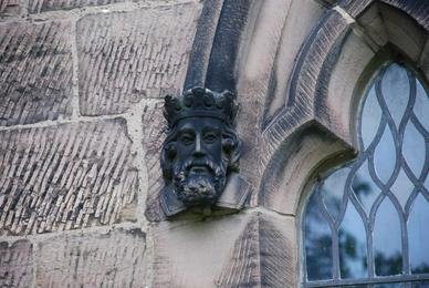 Place-Names gives it as the Old English wulf-leah or wolf wood. Either way, a nice origination.
In 1379 according to the poll tax records the village headman was John de Ullay a frankeleyn or freeholder. There is a lot of modern building around the village, often distracting from the older dwellings. A flashy modern house in light-coloured stone obscures the Old Rectory, a fine Victorian house in dark brick. The “Old School House” and “Old Post Office” record the loss of amenities. There is still a working farm in the village centre though. The church hall is forlorn with broken windows. Opposite is the Church of the Holy Trinity – locked of course. In 1650 the Parliamentary Commission made the following recommendation to the Church Commissioners: “We think fit that a church be built in Mr. Thomas Lawd’s Close, for Brampton, Ulley and all Morthen to resort to, to be annexed and made one parish, and divided from Treeton, the nearest being a mile and a half away from Treeton Church.” However, the church was not built until 1851, being paid for by Sir Charles Wood (who was successively Chancellor of the Exchequer, First Lord of the Admiralty, Secretary of State for India and finally Lord Privy Seal; he was created first Lord Halifax in 1866. When Chancellor of the Exchequer in Lord Russell’s government he was responsible for keeping relief for the Irish Famine to a minimum). There is a coat of arms on the wall of the church, but I cannot establish whose they are. At the corner of the arch of each window a small carved head is situated. I head back down through the village and then down Reservoir Road. Dill the Dog breathes noisily these days but keeps going. Great Tits and Blackbirds are in the bushes beside the road, which turns over a multi-arched bridge across the reservoir. A path, frequented by Wrens and Long-tailed Tits leads back to the visitor centre. Young people are launching canoes on the water.
Whiston – A village back towards Rotherham. The Concise Oxford Dictionary of British Place-Names states the name Whiston comes from two Old English words wite and stan meaning “The whitestone”. The name is referred to as Widestan, Widestham, and Witestan,in the Domesday Book. The village was in the hands of Thorketill pre-Conquest, after which it was handed to the Earl of Mortain, William’s half-brother. In the 13th century, it was in the possession of the Lovetots, Lord of the Manor of Sheffield. At this time the manorial barn was erected. This is one of the oldest agricultural buildings remaining in the country. The northern part was added in the 16th century and the wooden walls replaced by stone. It was a tithe barn, where the tithes for church were stored. In the 19th century a “Gin House”, a horse driven threshing machine, was added. The barn fell into disrepair as its use diminished but was bought in 1985 by the Parish Council and restored, its thatch being replaced by Polish workers in 1991. Beside the barn is the Hall, a large imposing set of buildings, now a nursing home. Towards the village centre, a delightful brook flows down a rocky bed. Up Brook Street there are cottages and small terraces. Over on the main road is the Methodist Church, built with what looks like crazy paving.
A ginnel climbs to School Hill where there are some fine old cottages and houses. Upwards and at the top of the hill is the church and a magnificent Rectory, dated 1844, 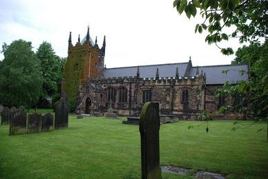 now in the possession of the Coal Industry Social Welfare Organisation (they had offices just down the road from our house, but these have been closed). The Church of St Mary Magdalene stands in an extensive graveyard with fine trees and open grass. According to “The Parish Church of St Mary Magdalene, Whiston” by John D. Griffin (1967), “In the 18th and 19th enturies it was usually described as “the Parish Church of St James”. Canon Raine, an eminent church historion of the 19th century, stated that “St James” was a modern ascription and that the original dedication was St Mary Magdalene. The “St James” ascription was most likely adopted under Puritan influence”. Most of the old work is 15th century, although the tower has a Norman base with a 13th century lancet, and a low pointed arch breaking into a Norman window. The bells are said to be 15th century. The monks of the Norman Abbey of St Wandrille, in 1188, claimed that Whiston was one of their chapelries. In 1883, the church was partly rebuilt under the direction of Mr J. Oldrid Scott , architect son of Sir George Gilbert Scott. The tower has a small slated roof and is covered on one side by ivy. The oaken lynchgate is the war memorial. Beside it is a set of stocks dated 1786. A fine chapel called Lynchgate Hall, now a private dwelling, stands by the entrance. A path and steep slippery steps (which I manage to fall down) leads back down to Hollowgate and the brook.
Tuesday 29th May – Scout Dike – It has been a disappointing Bank Holiday weekend, raining on and off every day. Clouds look heavy and pregnant with moisture this morning and are being driven by a breeze. On the reservoir and over the dam bank there are dozens of Swifts, Swallows and House Martins. The Swifts, in particular, are sweeping close to me. I try to photograph them, but despite over one hundred shots I fail to get a good one. Blackbirds and Robins are singing in the conifer wood at the bottom of the dam. Along the far side of the reservoir, Linnets and Dunnocks are singing. Coots have young. A Carrion Crow stands by the edge of the water and is watched warily by a nervous Coot. Goat Willow catkins are turning to white fluff. Down towards the bottom corner of the reservoir, where one of the streams enters, there is another mass of Swifts and hirundines. A Cormorant glides in. A Magpie is staking around a meadow of yellow buttercups. Long-tail Tits have formed family flocks and chase through the willows squeaking. Bright yellow Broom flowers coat the slope up to the car park.
Wednesday 30th May – Hemingfield – Last night was cold enough to give some places a frost. It does not look as though the temperatures dropped that low around here, so the flowering Broad Beans and newly planted French Beans should be all right. This morning is bright and sunny. Hemingfield is a former pit village to the south of Barnsley. The pit, known as either Hemingfield or Elsecar Low Colliery, was sunk in 1840 and owned by Earl Fitzwilliam. The pit closed in 1920 and its headgear was removed in 1935. The village was home to John Birks, known as “The Honest Lawyer”. He practised mainly in Barnsley, having rooms at the Three Cranes and donated money to build the National School in Hemingfield. He died in 1860. A footpath runs down beside the Barnsley-Sheffield railway line. The path is a green tunnel as Hawthorn bushes meet overhead. As the path opens up above, it becomes very overgrown with vicious Stinging Nettles and Cow Parsley. A little further on these have been trampled down over the path making it awkward for me and downright difficult for Dill the Dog to walk on. Eventually, the path opens out into a field. Across the field and down another path by a mixture of new build and Council housing.
The path opens out into a new estate on the edge of Elsecar. The density of housing always amazes me, look out of a window straight at another house. The entrance to the housing estate is close to where the Dearne and Dove canal passes under the road and enters the Elsecar basin. I head off back down the canal. It passes through several drops that were once locks. There are dense reed beds in many areas which obscures the original shape of the canal. Elderflowers are everywhere. Oxeye Daisies, happy yellow faces in a white ruff, are common. The flower spike of Burdock is rising out of the centre of huge leaves. There is a canal basin, the entrance is filled in, and the water covered with algae through which a couple of Coot plough a trough. A Sedge Warbler is singing (strangely, the first I have heard this year), also a Whitethroat and there is a quick burst of song that sounds like Grasshopper Warbler, but it is not repeated. Guelder Rose is blossoming, the larger, sterile outer flowers on the heads opening first. Nearing Tingle Bridge and there are yet more new houses. The Elephant and Castle has been refurbished. A little up Tingle Bridge Lane is a footpath that leads back up the hill. Halfway up the hill is an abandoned farm site – empty chicken and pig houses, sadly all derelict – just a pair of geese wandering around. The path comes out by the Fiddlers Inn, which has a barn beside it, faintly advertising Bentley’s Beers on its side – a closed brewery now of course. Back at the car, I notice a fine pigeon loft on the other side of the wall.
Thursday 31st May – Netherton – A village in West Yorkshire on the hills above the Calder and Hebble Navigation. The village was originally named “Nether Shitlington”, but this was changed around the 1860s (although the Local Government parish was still called Shitlington in the 1930s. Exactly when the name offended sensibilities and the “h” was dropped is unclear.) The name seems to have come from the Old English tribal name Scytlingas. The village once had two collieries - Denby Grange and Bullcliffe Wood. A path runs down from the Community Centre. There are wonderful panoramic views across to Wakefield, over Horbury Junction and Ossett rising above it and north to Thornhill.  Wakefield Town Hall and Cathedral and Ossett Parish Church rise above the respective skylines. House Sparrows are noisily clustered around the beginning of the path that drops down past fields of barley to Stony Cliffe Wood. On older maps however, this area of wood was called Perkins Wood and the southern section was known as Stony Cliffe Wood. Here the path descends steeply through mainly Oak woodland to a small lake. Some of the Oaks are twisted and bent into
 wondrous shapes. A couple of Mallard are on the water whilst others are asleep on the far bank. Stony Cliffe Beck feeds the lake. The little stream meanders through the woodland as the path heads west. The path is part of the Cal-Der-Went Walk. Numerous Blackbirds are singing or chasing through the trees. A strong musty scent of garlic permeates the air, although the source, Ransoms, have finished flowering and are withering away. Several Great Spotted Woodpeckers are chipping from the branches although the only one I espy is down at the base of a small sapling. A Chiffchaff is calling loudly. A bench makes a welcome break beside the stream, the sun flickering through the leaves. Dill the Dog has a quick paddle and drink. The path climbs up the steep hill. The Oaks become far less dense and many Silver Birch are growing here. One Sweet Chestnut has a single large trunk and two stumps. Maybe, someone cut the original tree down perhaps before the Second World War. The tree grew again and was cut down again, maybe in the 60s. Now the third trunk has reached up to the sky in a display of determination to be part of the landscape. A large, deep hole is evidence on the quarrying that took place here in the past. A large Ash has thick sinews of Ivy welded to its bark. Grey Squirrels are common. Back up towards Netherton several long, orange slugs cross the path along with a scarlet ladybird. Skylarks are singing from the heavens.